10. Transport and Street Network
Main directions of city transport system development are directed to form a high-efficiency transport complex with an ability to meet needs of citizens as regards relevant services and minimize an adverse affect upon environment.
In pursuance of this objective main directions of transport complex development are the following:
- priority of public passenger transport when providing city transportations;
- development of high-speed out-of-street modes of rail transport (subway, high-speed trams and railway);
- forming a complex system of transfer hubs at stations of city railway and subway lines, and also bus terminals and stations;
- provision of high-speed, comfortable and safe transport connection between all functional areas of the capital based on increase of street network density, construction of transport passages through the Dnieper River, liquidation of disproportions between its traffic performances and necessity of increasing a traffi c intensity;
- discharge of city street network by reducing transit transport traffic and creating a system of by-pass highways with regard being taken as to directions of international transport corridors and needs of further territorial development of the city;
- formation of transportation-logistical clusters within the framework of construction of international transportation corridors;
- launching automated system for traffic management and administration;
- constructing underground and surface multilevel parking lots in rural areas of the city and nearby the transfer hubs;
- restricting car access to the centre of the city.
І. City public passenger transport
Development of city passenger transport is focused on transportation provision of designated territorial development of the city, including but not limited to development of new residential areas in its suburbs and remote areas.
In pursuance of these objectives a further development of high-speed rail transport is expected, its base being formed by subway, high-speed tram and railway.
Development of surface passenger transport route network (tram, trolley-bus and bus) is governed by development of high-speed rail transport and ensures transportation of passengers to their stations. The network running through the whole city, services the directions with no high-speed rail transport lines.
High-speed rail transport
Prospective scheme of high-speed rail transport development provides for further development of subway, high-speed tram and railway as a unified system of general municipal passenger transport with organization of complex transfer hubs being made.
High-speed rail transport-scheme
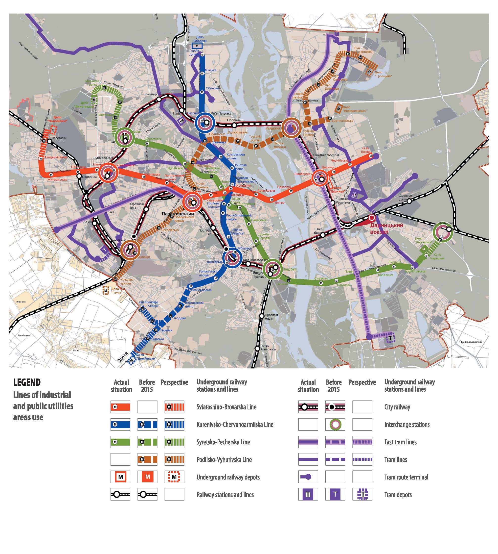
Subway
Subway development scheme provides for extension of three existing lines and construction of a new one (total length of the lines – 103.0 km, number of stations 81, transfer hubs between subway lines – 6).
Sviatoshyno-Brovarska line shall be extended along Palladina Avenue to the “Novobilychi” station to be located at so named railway and bus stations. In addition, the following shall be put into operation: second entrance-exits to/from “Vokzalna”,“University” and “Darnytsia” stations to be introduced; second transfer hub between the stations of “Zoloti Vorota” and “Teatralna”, three lowering stations (two at the existing stations and one on the territory of tram depot “Darnytsia”) in order to support a power supply system, road, for running subway wagons (trains) after repair, at the ferrying between “Darnytsia” and “Chernihivska” stations.
Kurenivska-Chervonoarmiyska line will be developed to the south, to the neighborhood unit of Teremky residential complex with branching in the area of Odesa Square. By the year 2025 it is planned to extend a subway line from “Vasylkivska” station to “Odeska” station and construct “Teremky” transfer depot. Moreover, there is also planned a construction of line forking into “Bus Station” and “Aurora Cruiser” stations, a second entrance-exit to/from “Respublikanskyi Stadium” (“Olimpiyska”) station, rolling stairs maintenance shops (for “Obolon” tram depot).
Syretsko-Pecherska line shall be extended to the northern west to residential complex Vynohradar and to the east to “Lisnytstvo” railway sta
tion. When extending line from “Syrets” station to “Syniozerna” station there is planned a construction of “Vynohradar” tram depot. In addition, station complexes “Lvivska Brama”,“Telychka” are planned to be finished, second entrance-exit to/from “Druzhba Narodiv” station to be put into operation.
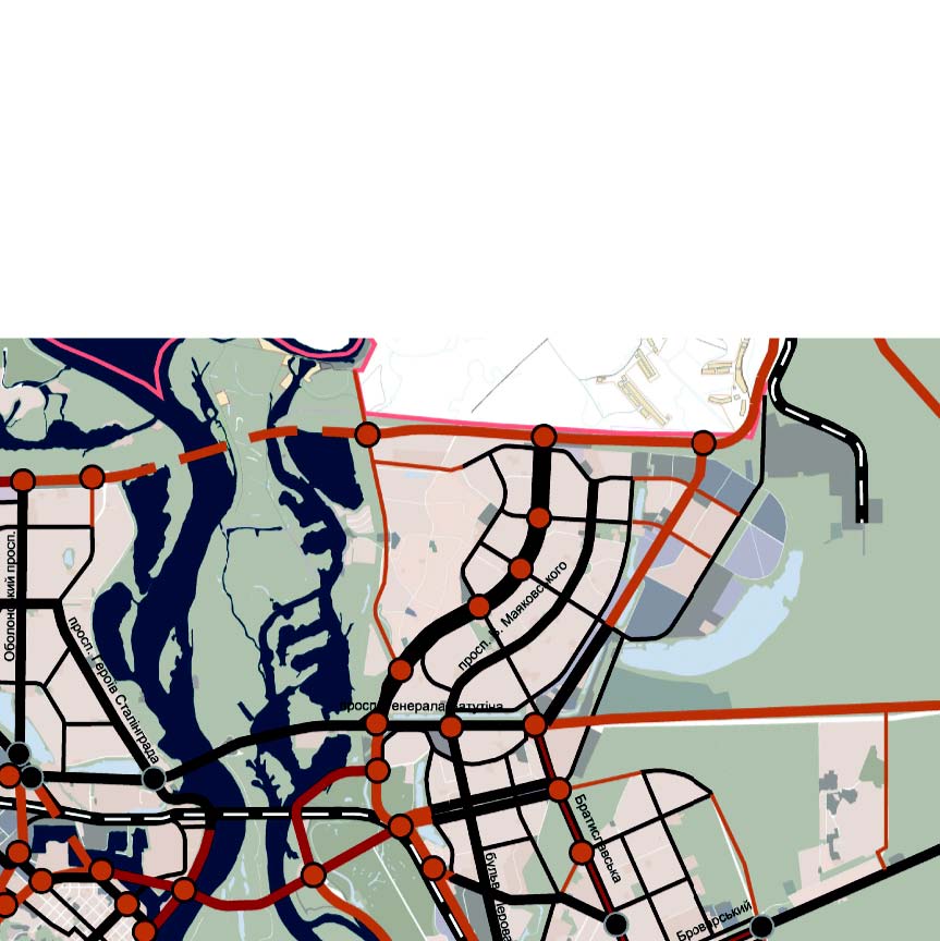
Podilsko-Voskresenska line will run from the northern west of the city from “Okruzhna Doroha” railway station in the area of Zhuliany highway interchange and further on via city center and Podilskyi bridge passage to residential areas of its northern-eastern part – Voskresenska – Kybalchycha and Vyhurivshchyna – Troyeshchyna. A left shore line will run on Suleymana Stalskoho Street to Bratyslavska Street with its further forking at Perova Boulevard – V.Mayakovskoho Avenue and further turn at M.Tsvetayevoyi Street and extension to the territory of multifunctional use and construction of transfer tram depot. Main tram depot “Voskresenske” of this line is designated to be constructed on the left shore following “Bratyslavska” station along Kraynia Street.
By the year 2025 it has been designated to construct Podilsko-Voskresenska line from “Kyiv-Pasazhyrskyi” station to “Bratyslavska” station with “Peremohy Square”, “Hlybochytska”, “Podilska”, “Sudnobudivelna”, “Trukhaniv Ostriv”, “Zatoka Desenka”, “Horodnia”, “Petrova Boulevard” stations.
In compliance with main directions for Kyiv subway by the year 2025 it has been planned to significantly increase a speed of construction of subway lines and stations and put into operation about 40.0 km lines, 32 stations, 5 additional entrance-exits to/from existing stations, and 3 tram depots.
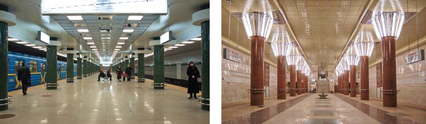
New subway stations
Main indicators of city passenger transport development
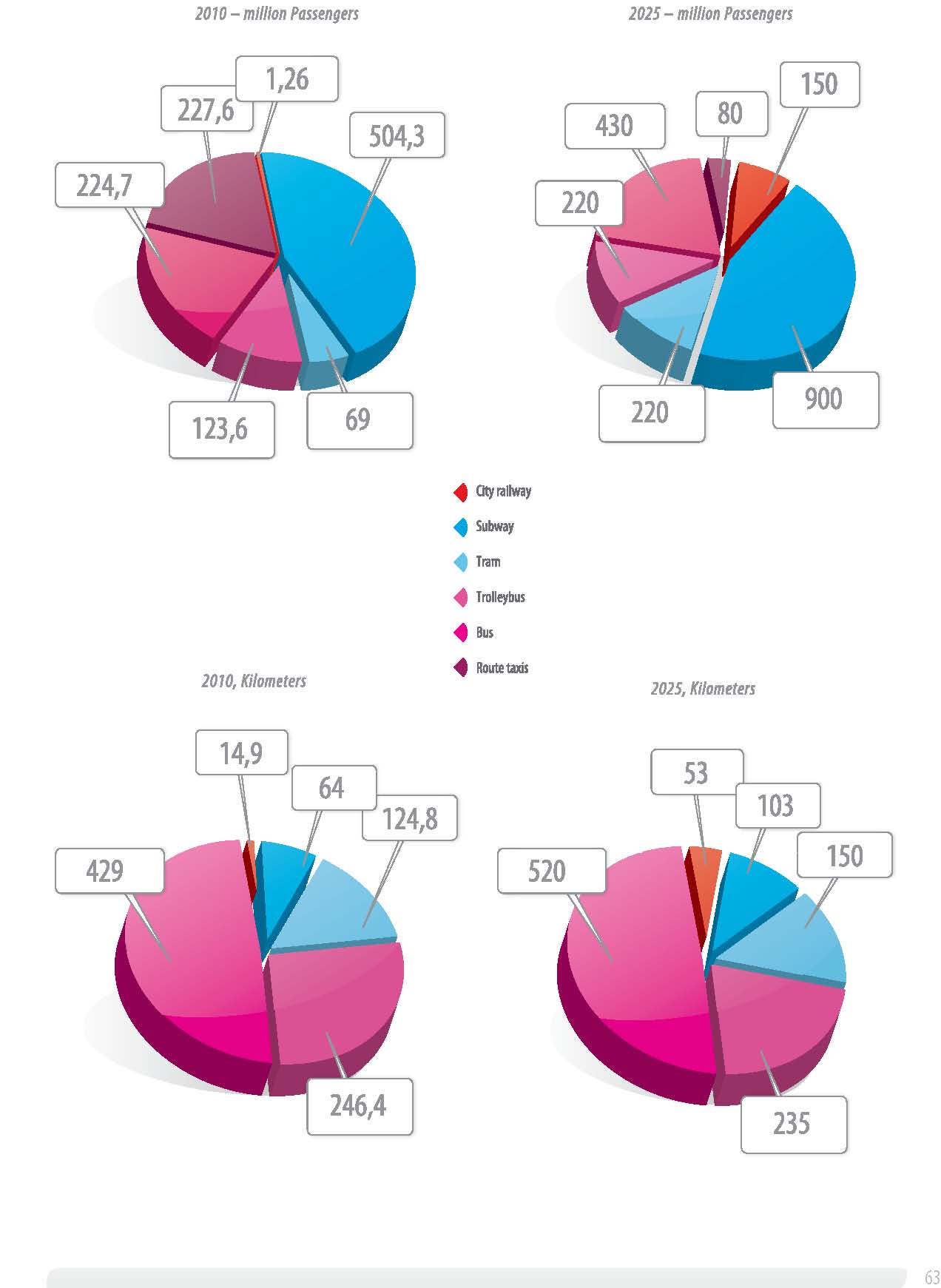
High-speed tram
High-speed tram development scheme provides for preservation of existing line “Peremohy Square – Circular Road” with its reconstruction and partial modification of highway in the area of railway terminal Kyiv-Pasazhyrskyi.
Also, it has been planned to extend construction of left shore high-speed tram line from residential complex Vyhurivshchyna – Troyeshchyna to Pivdenni Osokorky.
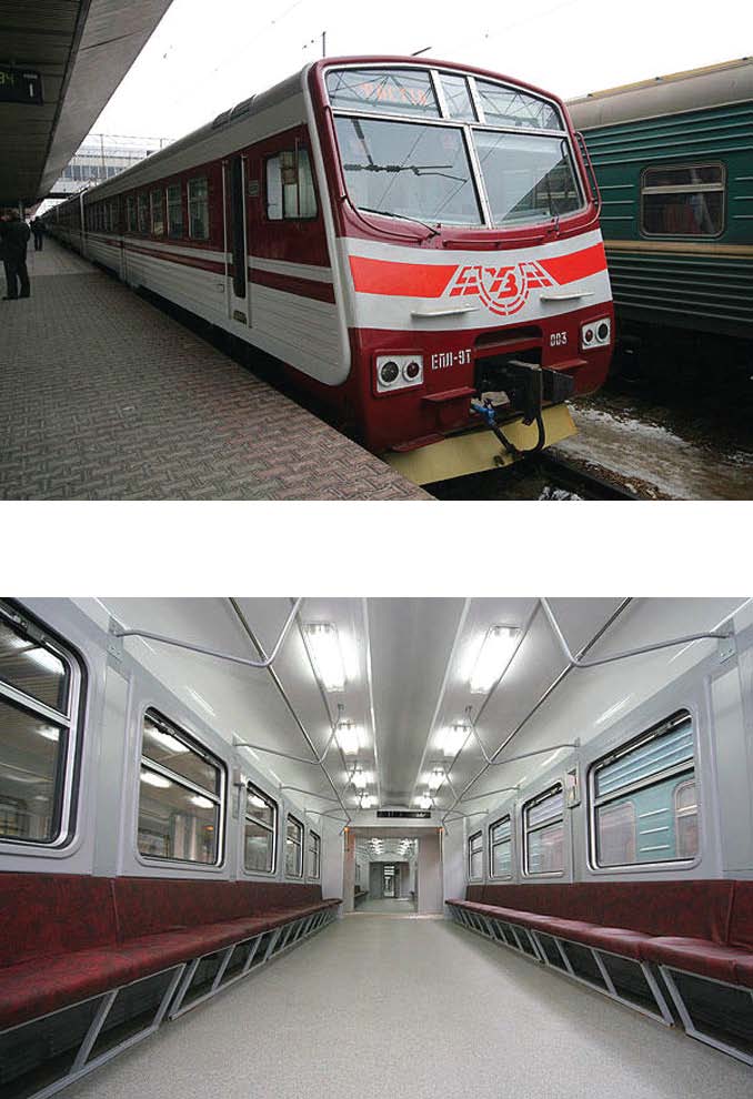
City railway
The Master Plan suggests an absolutely different approach for using of Kyiv railway hub. There has been planned a maximum discharge of inter
city railway lines from freight traffic and use of trams in the unified system with subway and high-speed trams.
The Master Plan long-term projects provide for arrangement of railway areas and buildings, opening of new station points which allow to the fullest extent to apply practically all railway intercity network for city routes, including connections with rural area towns (Vyshhorod, Brovary, Boryspil, Ukrayinka, Vasylkiv, Irpin etc.).
To provide the maximum use of railway for intercity passenger traffic there is a need to reconstruct a one line Petrivka railway bridge and construct a second line.
Surface passenger transport
Tram
It has been planned to quit the unreasonable practice of withdrawing tram lines when reconstructing street network in order to increase its traffic performances. Tram lines are expected to be reconstructed and arranged in compliance with the European Standards on the use of railway road-bed modern structures which allows motor vehicles to pass, and in the places of necessity they should be allocated to the separate roadbed, provided all conditions for route management with a high-speed traffic are created. By the year 2025 there is expected a construction of tram lines on Vidradnyi Avenue, Pryvokzalna Street – Prazka Street and further construction of tunnel passage under railway lines in Boryspilska Street. Withdrawal of tram tracks is provided only on the routes with small passenger traffic, or in case such withdrawal is affected by city development factors: on Naberezhne Shose, Bratska Street, Kharkivske Shose etc.
Trolley-bus. Bus
Trolley-bus lines and bus routes are developed to connect districts, in the newly-built districts and as a transport mode to deliver passenger to high-speed rail transport stations (subway, high-speed tram, railway) which are under construction.
Trolley-bus network will be supplemented with new lines.
In the long view a gradual withdrawal of trolley-bus routes from highway street network is planned, and its further substitution with bus routes.
Implementation of designated efforts will materially improve transportation services for the citizens, ensure comfortable conditions for passenger traffic, transport connections between places of residence, work and public services centers, mean time of city travel will be reduced from 60-90 to 30-45 minutes.
Suburban electric train new line
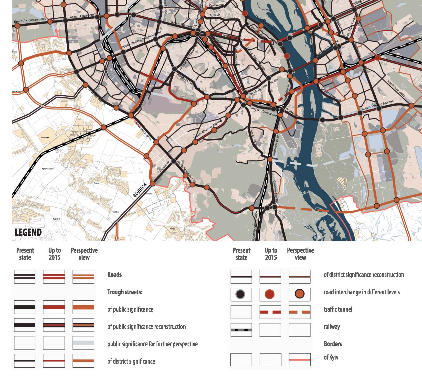
ІІ. Street network
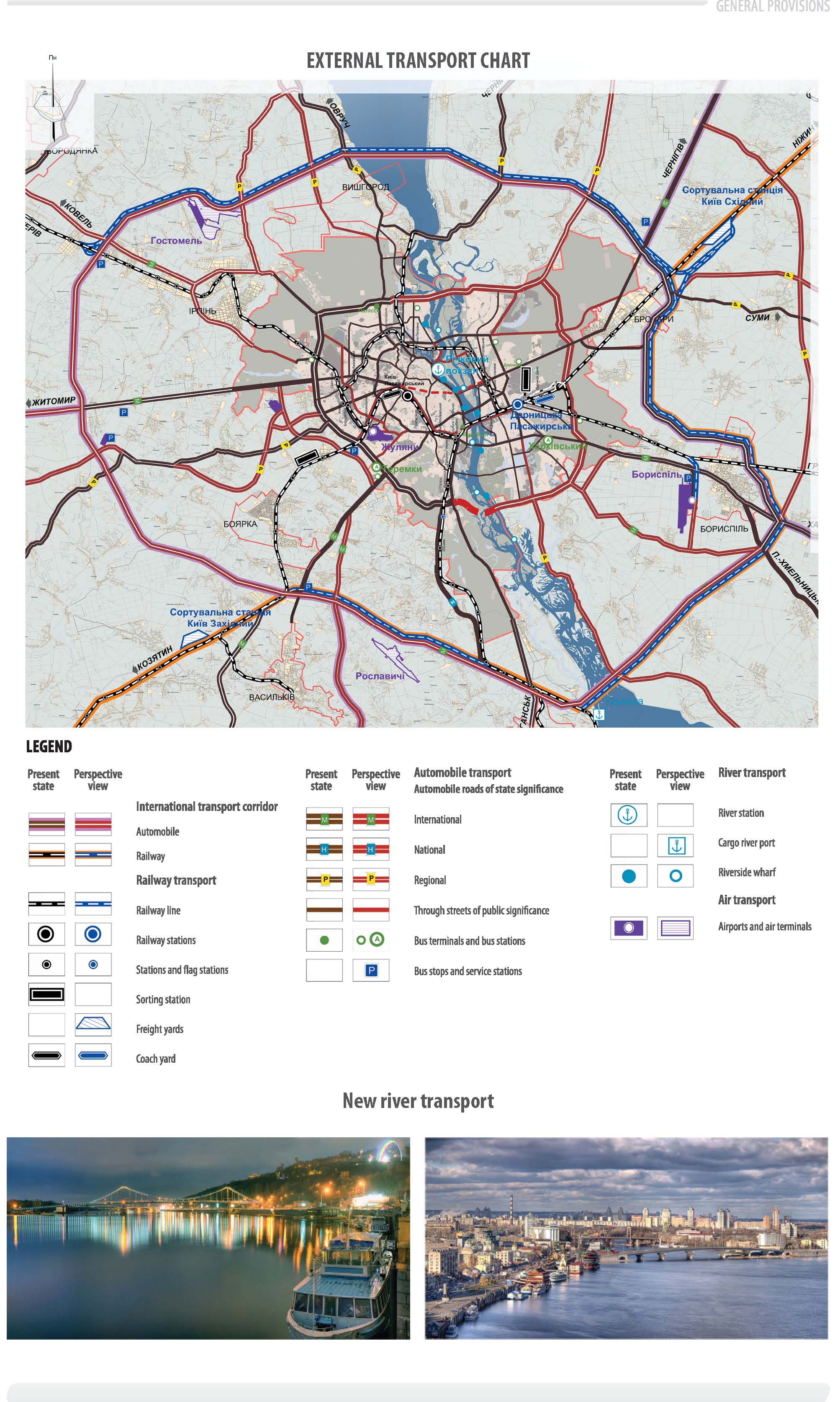
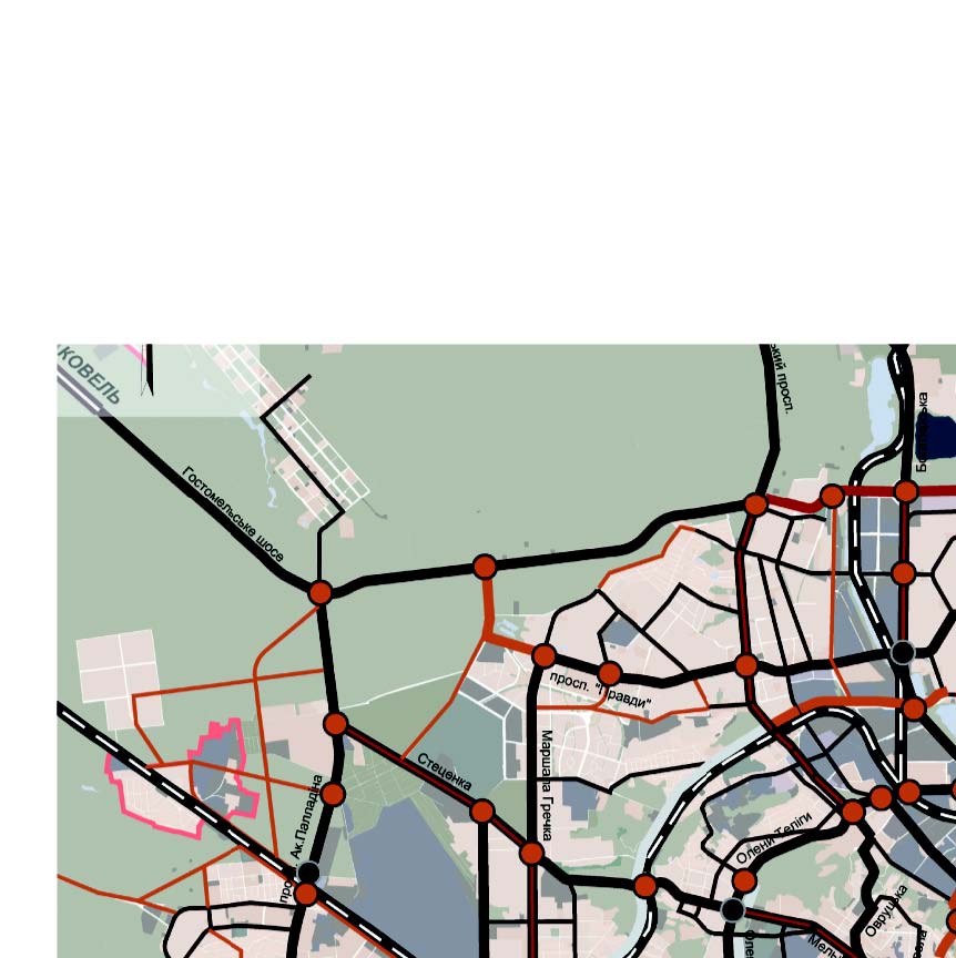
11 national highways meet Kyiv City: 6 main highways and 5 regional highways. The basis of the City street network is radial main highways
– extension of external road approaches from the direction of Ovruch, Kovel, Chop, Odesa, Lugansk, Kharkiv and Chernigov, two semi-annular main highways on the right bank and two lots of meridional main highways – on the left bank.
The main measures for development of the street network provides further complex development of junction of external motor roads and the City highway network inclusive of directions of Kyiv territorial development and international transport corridors which go through Ukraine.
These measures are directed for creation of system of continuous movement main highways and development of the formed system of main highways. On the right bank – further development of radial-circular structure by means of construction and reconstruction of new and old radial directions, improvement of semi-circular main highways and beginning of creation of external road bypass of City ring road (MKAD).
On the left bank – creation of new latitude and meridional directions, reconstruction of existing ones.
Majority of measures intended to be performed till 2025, are directed for increase of density and rise of the network capacity.
Transport ways. Tunnels.
The basic element in structure of main highway of Kyiv is transport ways through Dnipro River providing connection between its right-bank and left-bank parts.
Construction of tunnels is necessary for increase of the street network density, maintenance of historical housing in the central part of the City and relief of transit flows on its streets.
It is proposed a construction of 8 traffic tunnels within Kyiv City for a long term.
It is intendedto build Northern and Southern tunnel junctions though Dnipro River till 2025. It is necessary for connecting of right-bank external road ring with the left bank and development of left-bank automobile bypass.
It is intended for a long term (after 2025 р.):
Tunnel from Naberezhno-Lugova st., to Bogatyrska st., which will connect municipal highways and will create continuous E-W connection.
Tunnel from Frunze st., to Kirovogradska st., is provided for in route of Mala Kiltseva Street, extension of which is impossible under conditions of existing construction.
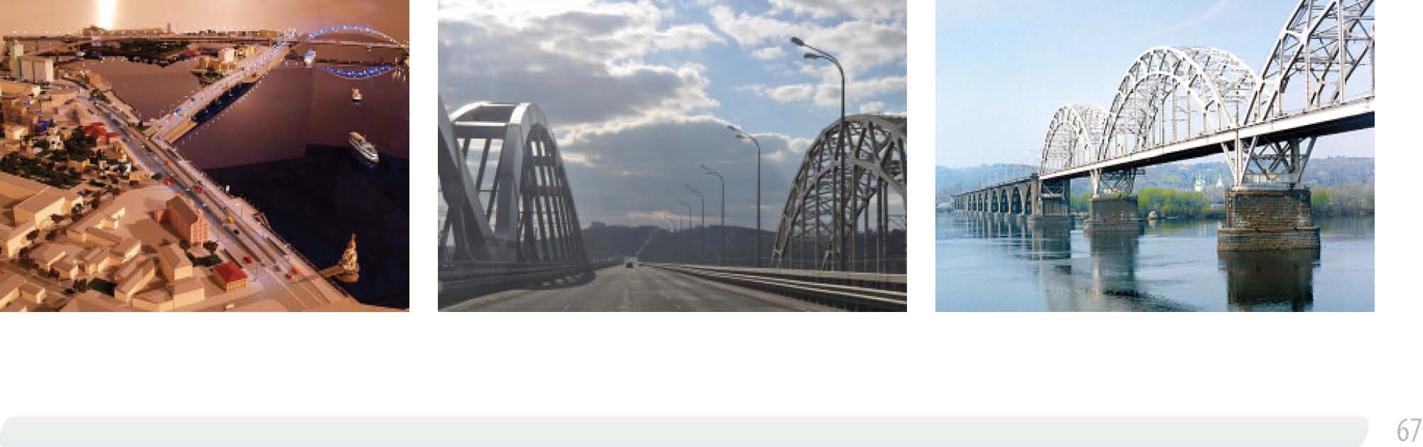
First of all it is necessary to increase capacity of connections between right-bank and left-bank parts of Kyiv City. It is intended to build two prior
ity high-way bridges (Podolskyi and Darnytskyi ones), to begin building of transport way in the north from Obolon, construction of transport way on extension of City ring road (MKAD) near Chapayevka village and reconstruction of Paton bridge.
There will be construction of East-West highway being a motor approach to Darnytsya railway-motor bridge crossing through Dnipro River.
One of the most important objects for left-bank territory is construction of highway from Kyiv-Chernigiv highway to Vatutin ave., in circumvention of town of Brovary that admits direction of connecting traffic from this powerful external direction directly to Moskovsky Bridge and Bogatyrska st., in circumvention of Dniprovskyi district blocks and narrow bridge “Metro”.
It is intended to create Troyeschyna-Osokorky meridial main highway – the main planning axis of left-bank territory which will go from the north of Troyeschyna in the route of Balzak st., further – along the railway to Poznyaky to Grygorenko ave., and it will go further to south together with building of Osokorky to the eastern part of the City ring road (MKAD).
The length of the main street network will be increased in 1.4 times, its capacity will be effectively used, jamming over crossing will be liquidated, automotive flows to the central part of the City will be low, safety of transport and pedestrian traffic will be achieved.
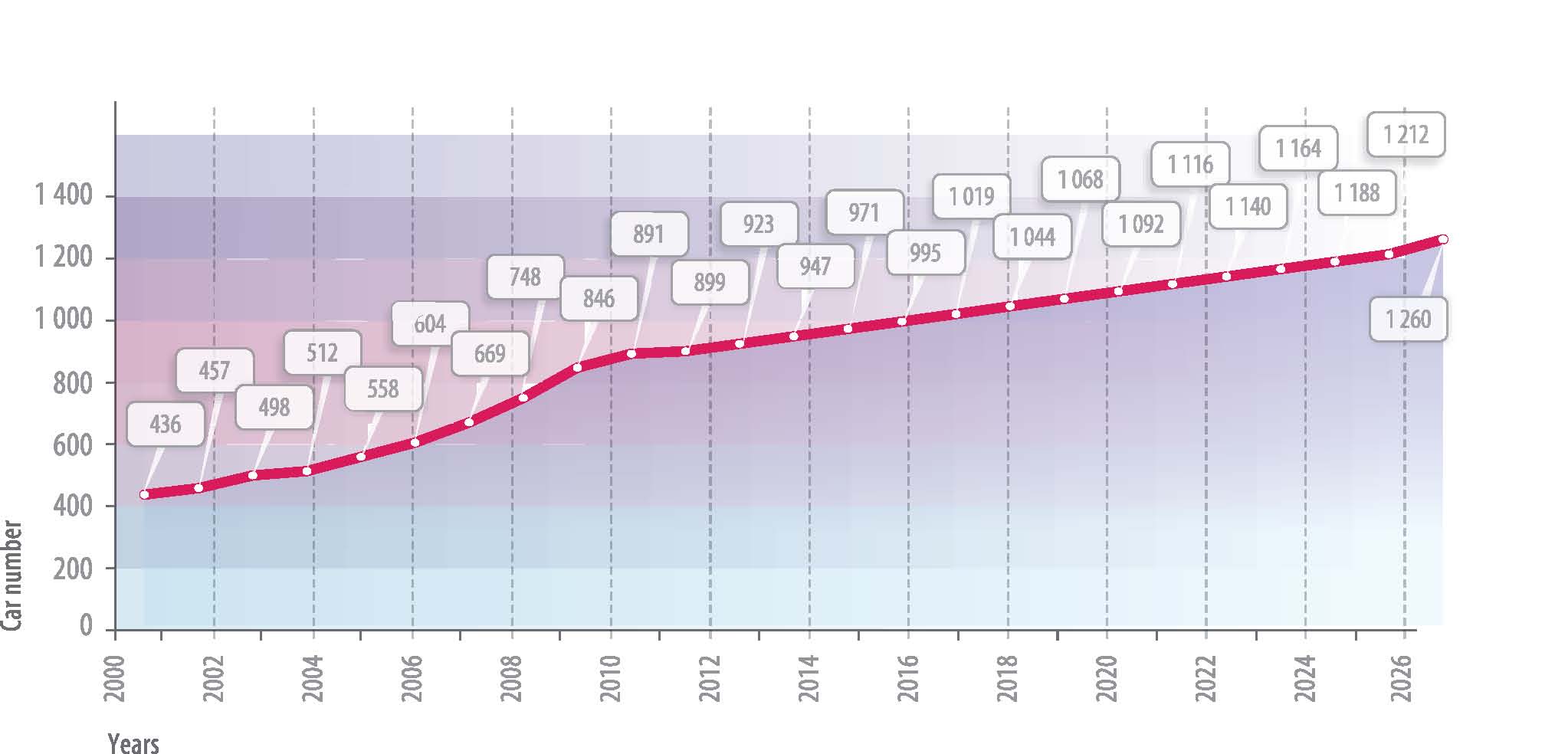
It is expected to have increase of quantity of auto park in 1.4 times at probable increase of automobilization level to 400 units for 1000 persons.
-
-
New bridges
Development of street network
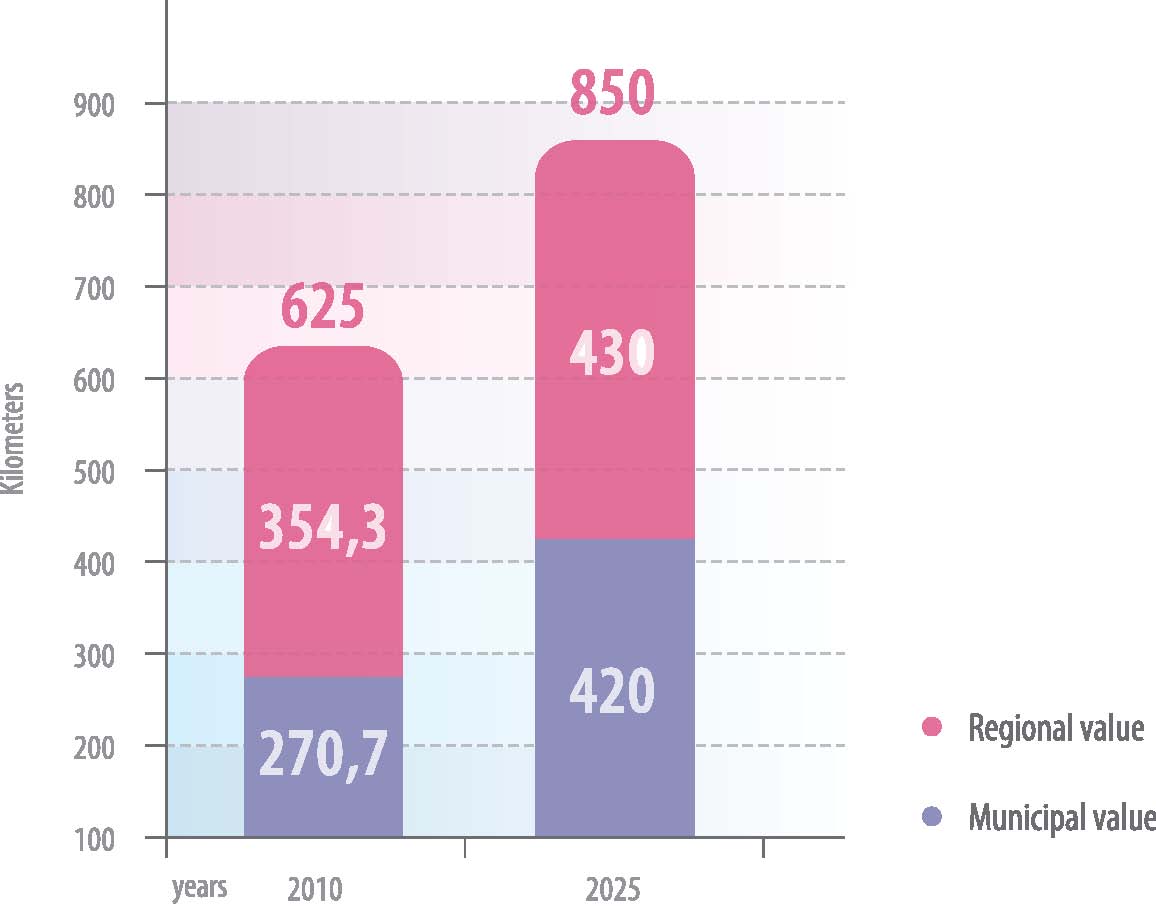
Dynamics of highway transport increase