3. Planning Structure of the City
Planning model of Kyiv development in the long-term outlook is considered as an open town-planning system – Kyiv and suburban areas (Kyiv agglomeration).
According to this model the agglomeration development of ensuring transport-planning links between areas of work application, residential areas, community centers and recreational areas is expected. The main focus of the system is in Kyiv city, and sub-systems are formed at the bridge – the district centers.
In the areas of the spatial impact of Kyiv city urban areas are formed, which develop along the transportation-planning areas in the system of international transport corridors for Kovel- Warsaw, Kyiv-Lugansk, Boryspil-Chernigiv-Moscow, Odessa-Istanbul.
Planning structure of the city consists of planning zones and provides the balance of natural and green areas of transport and engineering infrastructure and the built-up residential and industrial areas, including:
- increase the area of public green areas;
- increase the area of main street network, transport and engineering infrastructure;
- formation of the system of public spaces for recreation, health, communication, public holidays, cultural, business, sports events (Khreshchatyk Street, Independence Square, the European Square, Kontractova Square, Andriivskyi Uzviz, Peizazhna Alley, Obolonska embankment, citywide public recreation center, which is formed in the catch of the Dnipro river, on the Dnipro islands and on coastal green bands “Dnipro Pearl”, “Cultural Valley” on the territory of the “Arts Arsenal”, new centers of business and cultural activities);
- openness of Kyiv settlement system to daily transport trips to employment, cultural, residential and recreational purposes.
The systematic development of all functional city areas and improvement of planning structure will include the following measures:
- in the Right Bank the city transformations from the radial structure, that has evolved historically, into radial semi-encircling one continue. Inner city semi-encircling links facing the water and green diameter and the bridges across the Dnipro should get particular importance;
- with the construction of new bridges, the links of the Left bank with the Right bank in the future will be transformed into a system, based on a combination of mutually perpendicular
- directions – external, directed to the Dnipro river (for bridges that are in increments of 2.5-3 km) and internal meridional, going along the river;
- radial semi-encircling planning system of the right-bank part is organically connected with the rectangular linear system that is developed along the left bank of the Dnipro river;
- along the radial transport and communication corridors of the right bank, the main elements of the planning of macrostructure are formed. Its basis is complex residential and industrial planning area with a population of about 500 thousand people, balanced on all terms of settlement and employment attraction, development of public services and recreation;
- a part of each planning area includes the existing project or area of business activity, industrial zones, based on industrial and residential areas and storage units, residential and recreational areas, as well as elements of the city center. Thus, at each area of external relations corresponding urban area sector is formed, the formation and development is expected in organic relationship with the surrounding suburbs sectors;
- at the next levels it is provided to make planning division of the territory of destination specifying components of its functional areas;
- residential areas are divided into districts, residential districts, microdistricts and group of quarters. Industrial and residential storage areas – the industrial and residential areas and storage units, groups of industrial and utility companies, warehouses and storehouses. Recreational areas are divided into recreational districts, groups of recreational facilities.Functional and planning hierarchy is also corresponding to organizational structure of community centers, planning zones and regions, centers of residential and industrial areas, as well as service centers in microdistricts.
Planning structure
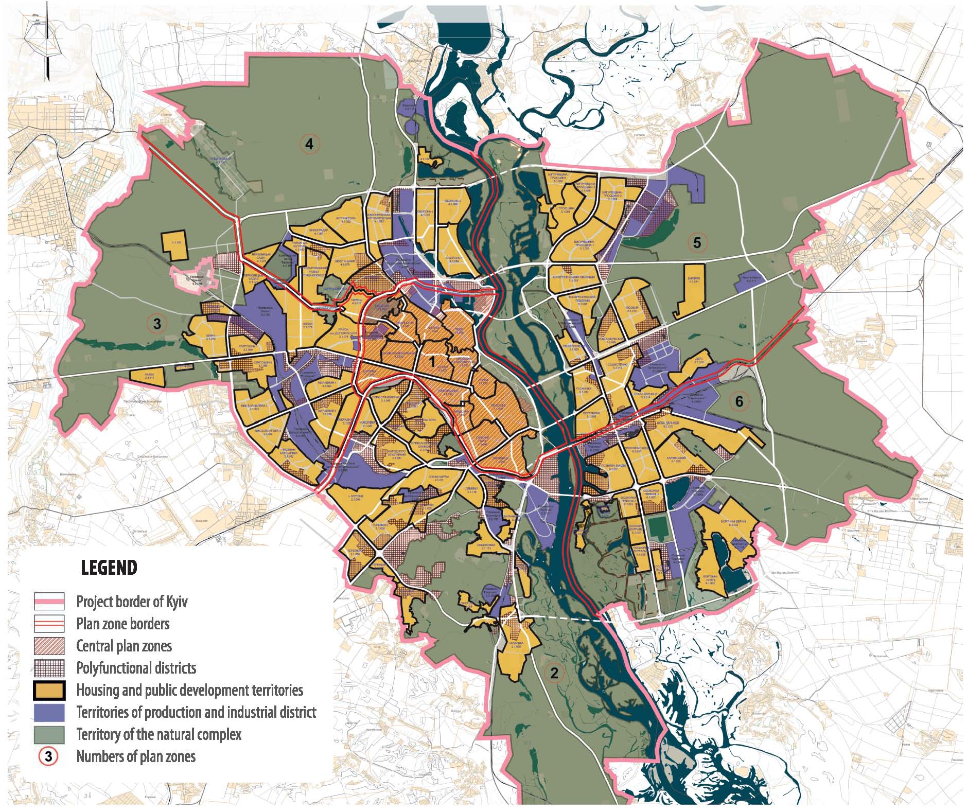
On the right bank
formation of four planning areas continues. In the central (first) planning area it is provided to:develop the areas for placement of state-administrative and political center of Ukraine, preserving and developing the tourism, hotel and residential, cultural and artistic functions of the Pecherskyi district;
- develop the areas of historical, craft and culture, exhibitions and shopping purposes, infrastructures of tourism, educational, cultural, exhi
-
bition and museum functions, allocation of international organizations, financial companies and banks, tourist river port, the preservation of housing and office building development and the social areas in the Podilskyi district;
- develop zones to accommodate the administrative and business, scientific, educational, shopping and entertainment, finance and banking, tourism and hotel facilities, preservation of residential and partly industrial functions, reconstruction of old housing mainly in Shevchenkivskyi district is being made.
In the southern right bank (second) planning areacomplex administrative and business, housing, scientific, industrial, recreational planning formations are developing with the formation of centers of health care, culture and sports, mainly in Golosiivskyi district.
In the western right-bank (third) planning area it is provided to:develop scientific and industrial, medical, housing, social service functions (mainly in Sviatoshynskyi district);
- develop the airport “Zhulyany” infrastructure, office-business, scientific, industrial, medical, residential functions in Solomianskyi district.
In the northern right-bank (fourth) planning area it is provided to:
• complete the formation of regional centers, the development of recreation and health, scientific, industrial, cultural, educational, commercial and entertainment functions, public and office centers, new construction of apartment complexes in Obolonskyi and Podilskyi districts.
On the left bankformation of two planning areas with the release of the central zone of the left bank of the city center in the area of
“Livoberezhna” metro station is continued.
In the central zone of the left bank it is provided to develop functions of the city center, tourist and recreation, banking and financial, administrative and business district of sports, cultural, educational and residential functions in the Dniprovskyi district.In the northern Left bank (fifth)planning area it is provided to develop the office-business, banking and financial, scientific, industrial, recreational and entertainment, sports and recreation, health, housing and social functions, mainly in Desnyanskyi and partly in the Dniprovskyi districts.
In Eastern South (sixth) planning areait is provided to develop the areas for placement of transportation and industrial, scientific and industrial, office and business, hotel and exhibition, shopping, recreation, cultural, educational, residential functions in Darnytskyi district. Along with improving the planning structure the architectural and spatial composition of buildings is improved.
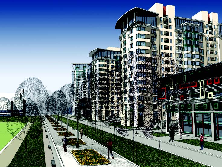
To improve the architectural and spatial composition it is provided to:preserve the dominant significance in the composition of the city, the dominant role of the first ridge of the right bank of Kyiv hills and attractions of cultural heritage – Kyiv-Pechersk Lavra, St. Sophia Cathedral, St. Andrew’s Church and other historical central part of Kyiv, the traditional character of buildings and landscape in historical areas, ensemble of Khreshchatyk, Volodymyrska streets and other historical streets;
- use of architectural and compositional techniques with regard to the nature of the existing building, the natural landscape factors in shaping the panorama building of the left and right banks of the Dnipro river and multilateral silhouette of the right-bank part of the city;
- find planning axes of transport and planning framework of the city together with creation of urban ensembles of the main thoroughfares and squares, emphasize landscape accents (valleys, hills, terraces, coastal, etc.);
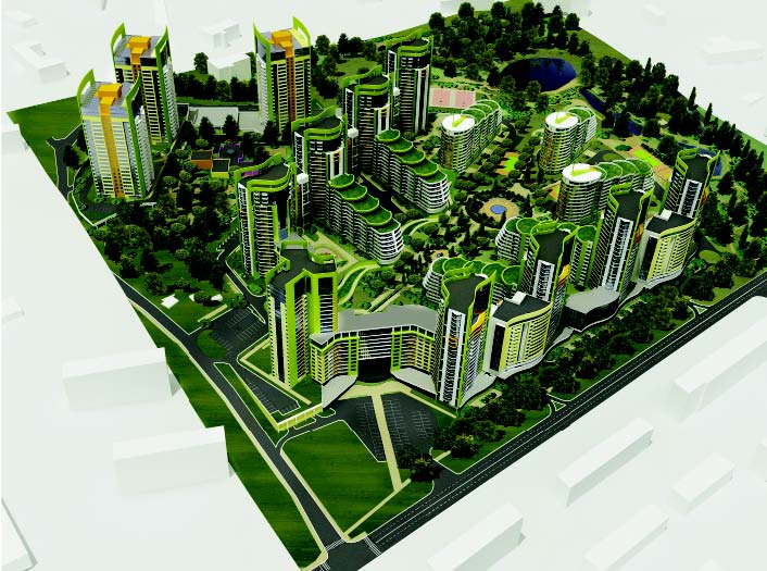
In order to preserve the traditional character of historical buildings, creating spatial dominants of the peripheral territories of Right Bank and Left Bank for the construction of high-rise buildings and complexes separate areas are determined, in particular on the entry highways in M.Bazhana Avenue and Kharkov highway (Kharkivska), near “Lisova” metro station, and in the Kioto Street (Chernigivska), at the intersection of Palladina Avenue and Peremohy Avenue (Zhytomyrska), in Glushkova Avenue and Ring Road (Odesska), at the intersection of the Stolychne Highway and Zabolotnogo Street (Dnipropetrovska).
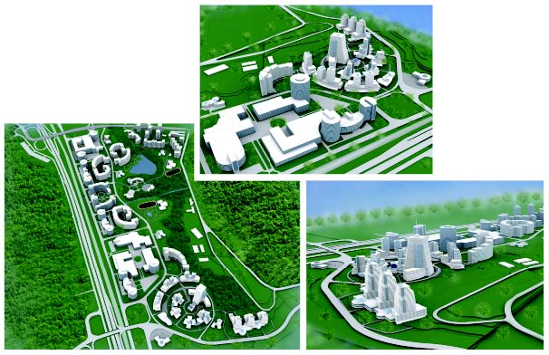
Innovative projects
The system of public centers
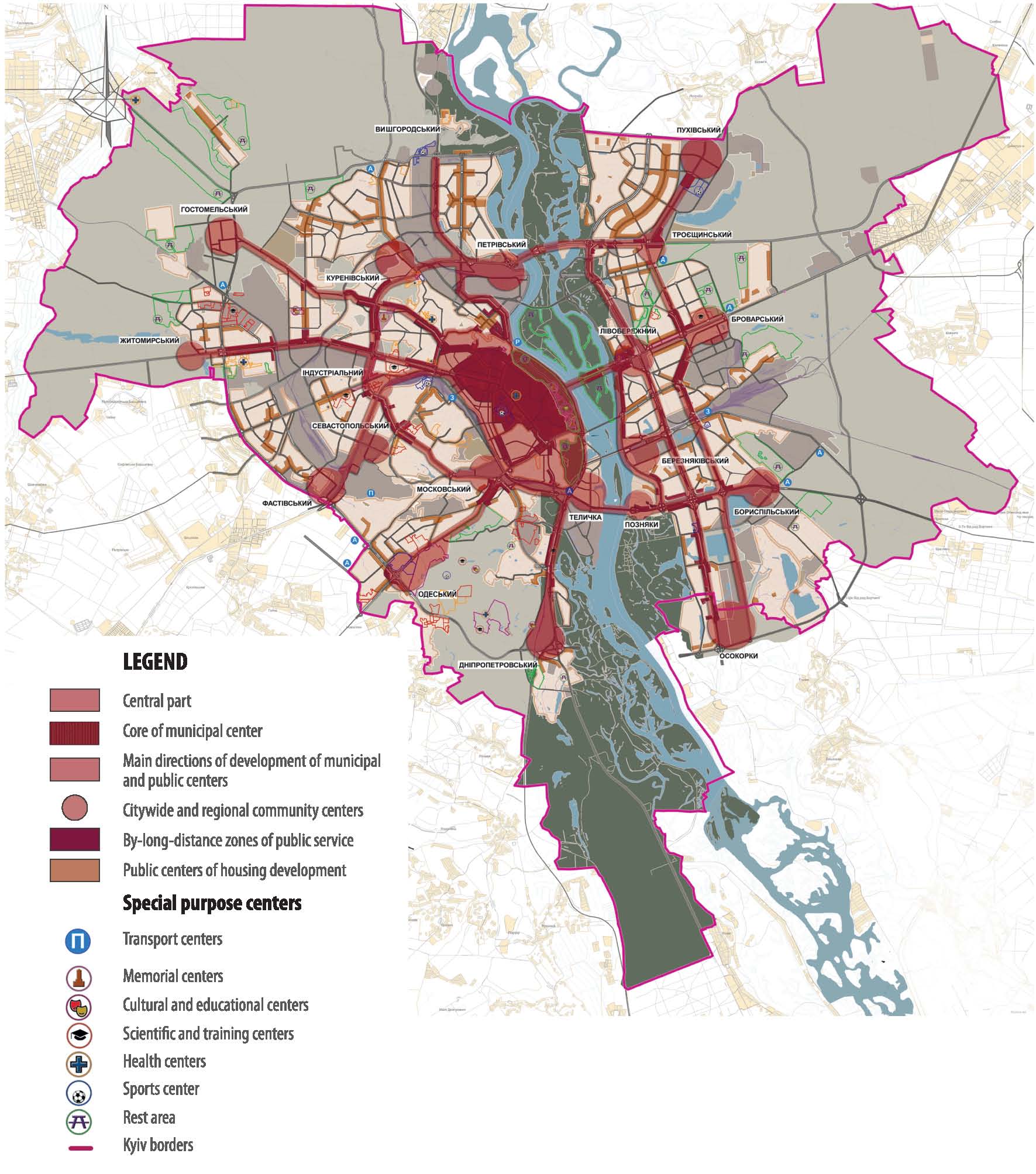
The system of public centers

High-rise building complexes can also be created at the intersection of transport routes outside of the downtown in particular.
Urban high-rise building complexes in certain places form the silhouette reference points of planning districts and cores of sub-centers of urban
and district importance, are the main elements of architectural and spatial composition of the city. High-rise building complexes must be designed on a competitive basis under a special procedure established by the central special competent authority in construction.
Placement of new high-rise buildings that may violate dominant role of national cultural heritage in the historical center of Kyiv and the historical areas is prohibited.System of city-wide centers
System of city-wide centers is developed on the basis of city planning framework and consists of a central core of the city-wide center, new
centers of business and cultural activity in the planning zones (near the stations of high-speed transport, transport interchange nodes), regional
centers of residential areas (in linear zones of business activity along the main planning axes highways.
In the central core and the planning zones specialized centers of administrative and managerial, cultural, spiritual and religious, memorial, shop ping and entertainment, scientific, educational, medical and other purposes are also formed.
The main architectural and spatial planning and the idea of the city center is the transition of polycentral structure and the creation of four meridional line-node systems development, as well as transition of the emphasis of center development from the right bank to the left bank of the Dnipro.For a balanced development of the city-wide centers it is provided:to limit the further allocation of offices and shopping facilities in the core of the city-wide center to reduce traffic in the central historic area of the city;
- to lead the city provision of administration and management facilities, finance and banks, scientific management, logistics, commerce and entertainment, hotel and travel services, exhibitions services to the level of provision of capital cities of Europe;
- preferential placement on the left bank of modern business and office business centers, shopping complexes, objects of financial and banking, hotel and tourism, exhibitions services for balancing employment and resettlement, especially in Darnytskyi and Desnyanskyi districts and in remote areas of the right bank;
- to define the investment-attractive areas to accommodate non-residential commercial real estate near metro stations and high-speed transport, at the entrances to the city;
- completion of the infrastructure of government, diplomatic missions of other countries, representatives of international organizations, financial and banking structures.
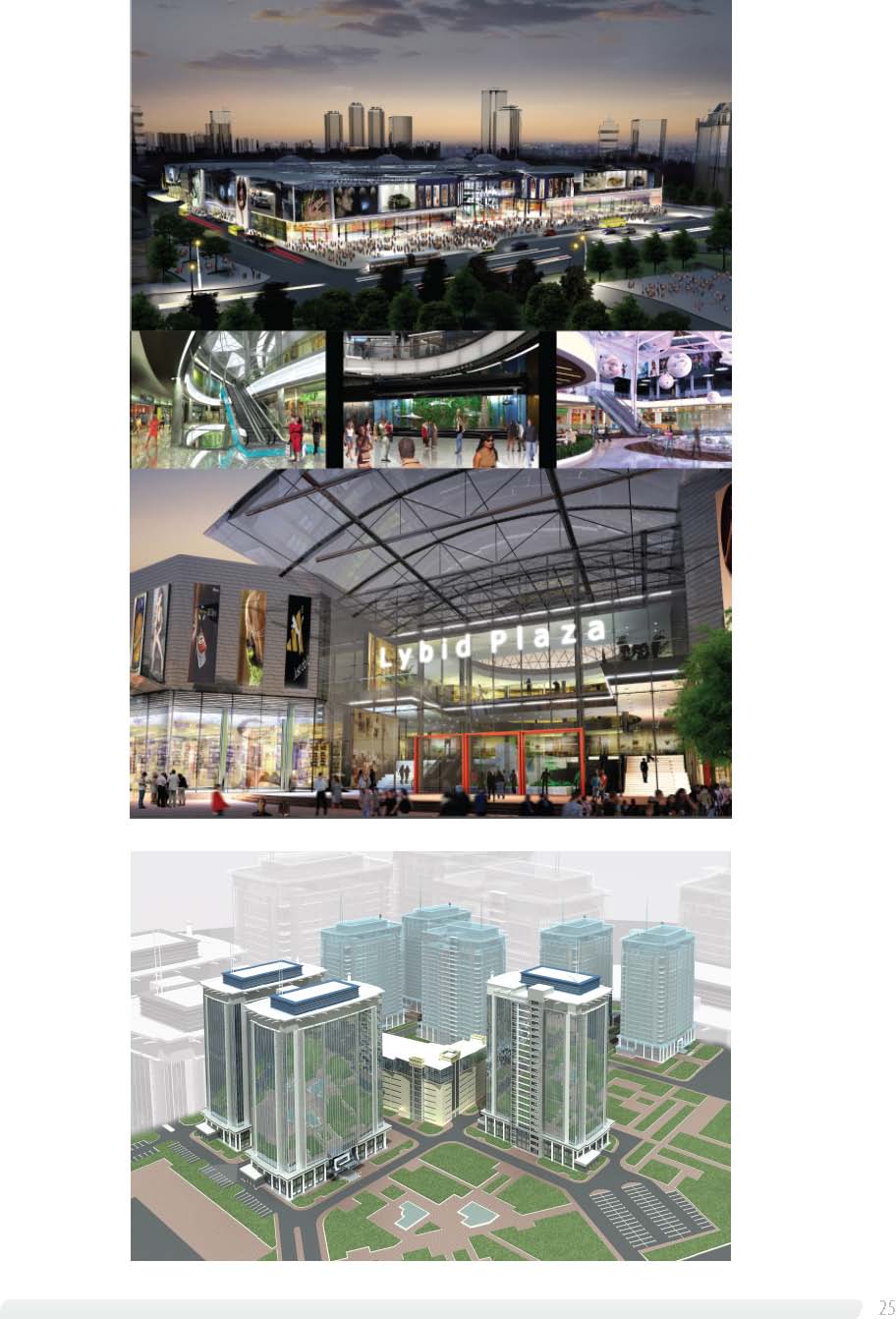
Projects of public facilities
The city-wide center.
Basic principles of the city-wide center development take into account the dominant role of the historic core of the
center. In the process of the subsequent formation of the city center focuses its development on the left bank of the Dnipro river in the area of
“Livoberezhna” metro station – Brovarskiy avenue, Dnipro embankments with more active floodplain areas – zones of mass rest – involvement
in its structure.
It is provided further territorial development of the core of the city-wide center within the central planning area. The amplification and integration functions of the center, its ensemble structure improvement with careful preservation and development of historical tradition of considering the current state of planning and development systems, main streets and squares that have been developed is provided in this area.
The first major line-nodal system of the city-wide center core are: specialized community centers, largely those, which have historically existed mainly administrative and business, cultural and educational destination, located on the crest of the right bank of the Dnipro river and the upper plateau, including buildings of President of Ukraine Administration, the Verkhovna Rada of Ukraine, Cabinet of Ministers of Ukraine.
Planning structure of the system provides the inclusion in its coastal parks, embankments and the upper plateau of the high right bank of the Dnipro river, its topography and expressive silhouette, national UNESCO monuments of Sophia of Kyiv and Kyiv-Pechersk Lavra, St. Andrew’s Church and St. Michael’s Monastery, Park of Great Patriotic War, “Vladimir’s Hill” and other parks, which will become a part of the tourist area “Dnipro pearl”.
The main planning axes of the city-wide center core is developed according to radial pattern along M.Grushevskogo Str., Khreshchatyk Str., Volodymyrska Str., Velyka Zhytomyrska Str., Tarasa Shevchenko boulevard, Lesya Ukrainka boulevard.
Development of the second line-node system is planned in the areas adjacent to the railway, which, along with Peremohy Avenue, the streets Zhylyanska, Saksaganskogo, V.Vasylkivska, Gorkogo, bind all the linear structure into a coherent whole.
-
The development of transport and pedestrian links in this part of central planning area allows to combine both slopes of the valley of the Lybid river – railway tracks – in the ensemble unity.
Creation of transport and pedestrian links in the direction perpendicular to the railroad, will allow to reconstruct that central part of this plan ning area from the Polytechnic Institute to Moscow Square and South Bridge.
Development of the third line-node system of city-wide public center in the left-bank part of the city is scheduled mainly within the territory of the Dnipro river to the railroad tracks.Its further development is foreseen in the direction from Rusanivski gardens in the north to the south of Poznyaky.
Development of the fourth line-node space system of the city-wide center is planned in the valley of the Dnipro river and the Dnipro islands – as the center for recreation and water sports of the city.
-
The development of this system involves its transformation into a highly well-appointed, intensively used area of parks, beaches, sports facilities, water stations.
Territories, attractive to investments
Ensuring the state interests
To perform the functions of the capital of Ukraine by Kyiv city and ensuring the state interests in planning and building of the city and suburbs it is provided to:
- create conditions for effective and safe operation of the Administration of the President of Ukraine, Verkhovna Rada of Ukraine, Cabinet of Ministers of Ukraine, ministries and other central executive bodies, including location, reconstruction and construction of administrative buildings, housing, social, cultural and community purpose objects, engineering and transport infrastructure and communications;
- develop infrastructure of foreign diplomatic missions to perform the Program of location of diplomatic missions, consular offi ces of foreign states, representatives of international organizations in Ukraine;
- make reservation of areas for development and support of government agencies, public institutions, science and education, health, culture and sports;
- construct exhibition and congressional premises for official national and international events – congresses, conferences, exhibitions and international meetings;
- fulfill tasks within the target state and international programs, including program development infrastructure to conduct the fi nals of European Football Championship EURO 2012;
- preserve cultural heritage of world and national significance;
- make reconstruction and development of unique cultural venues, creating national culture and art museum complex “Arts Arsenal”;
- protect natural reserve fund of national importance, to develop national ecological network;
- implement targeted state programs in the development of external transport, roads, information and communication, defense and secu
rity, energy, space, natural monopolies, energy and resource conservation;
- fulfill tasks of targeted state programs in the city territory, relating to the powers of the state of Ukraine and fulfillment of its international obligations.
Territories for the development of public, business
and other commercial non-residential building, attractive to investments
Currently one of the most important tasks of the city is improving its investment attractiveness, primarily for capital investments. They provide
real development of the territory and have a significant multiplier effect on overall economic activity.
Capital investments are crucial for urban development of the city – its social development, manufacturing, engineering, transport and environmental infrastructure. In turn, the existing level of infrastructural arrangement of the territory is an important factor in the investment attractiveness of the city as a whole and its individual regions. Pricing of urban land market is influenced by many factors: economic, social, political,
cultural ones, that determine the behavior of market participants and substantially affect the price level of demand and supply.However, within the city a crucial role in the differentiation of the price of land will be played by such town planning factors:
- transport accessibility (accessibility to the city center, community centers, places of application of labor, settlement, mass recreation);
- the level of engineering construction of the territory;
- its historical, cultural and natural landscape value;
- environmental condition;
- social and economic development.
- That is, those factors that in their totality determine the of urban planning value of the territory of separate city districts.
In the next years the city of Kyiv will experience the public, business and commercial development. This development will be increased, because
of the level of business activity in the city increasing due to new development and intensification of already-used areas of the city. These areas
are as follows: - lands, free of building (wastelands, non-convenient lands, marshy meadows and woodlands, which have no prospects for the development of complex natural objects, etc.);
- the territories of the industrial enterprises that actually stopped their activities, as objects of national economy, have low effi ciency of management, improvement and they are environmentally dangerous;
- the territories of the institutions and enterprises which change the line of their economic activities.
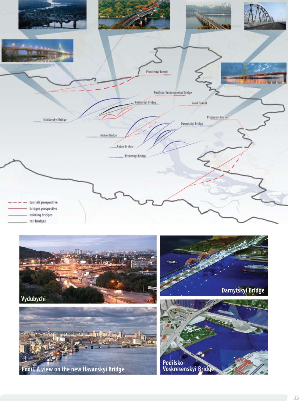
Projects of public-transport systems, new bridges, railway stations