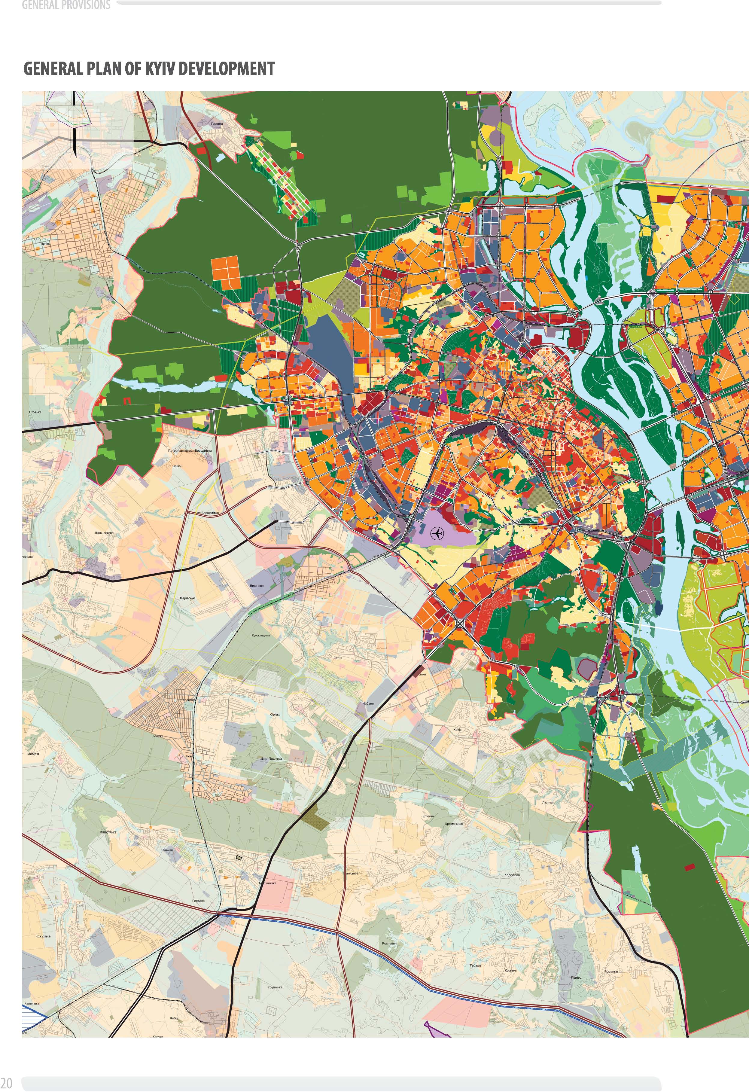
2. Territorial Resources
- Characteristics and scope of territorial resources of the city. The city territory is 83,558 hectares. The city is divided into the following lands, according to functional purposes: residential and public buildings (13,777.2 hectares or 16.4%), industrial, utility and storage facilities and external transport (8,536.0 hectares or 10.2%), transport infrastructure, streets and roads (4,341.8 hectares or 5.2%), landscape and recreation and green space for general use (49,133.52 hectares or 58.80%), water surface (5935.31 hectares or 7.1%) agricultural land (940.52 hectares or 1.1%), other (2705.96 hectares or 3.2%).
Territorial resources of the city, taking into account environmental and urban planning area assessment, currently consist of the following lands:
- free, conditionally free lands, allocated and undeveloped in previous years, construction in progress;
- microdistricts and neighborhoods of older housing stock;
- industrial and residential storage purposes lands, which are used irrationally;
- special purposes lands, on which housing for military personnel can be located;
- agricultural lands.
More effective use of built-up areas can also be a resource for development.
Intensity of use and density of buildings in the city is 1.4 – 1.6 times inferior to the corresponding parameters of the similar capital cities of Europe. More than 50% of existing microdistricts of the existing high-rise building housing have the density and population less than normative by 30-40%.
This primarily applies to microdistricts with five-storey buildings of 60–70s years of the last century.
The volume of available local resources within the city for residential and public buildings is up to 5490.0 hectares, including the territorial resources to accommodate commercial development and other facilities located separately of multifunctional public and business development2.8 hectares of the left bank of the center that has already emerged –3417.9 hectares or 15.9 square meters per 1 person. The main problem is the imbalance use of residential area in certain areas of the city, lack of green areas for general use.
Estimated population by the year 2025 adopted by 20% belowpotential demographic capacity of residential areas to eliminate disparities and
The need of territories for perspective population is:For housing, taking into account the estimated housing provision–2.8 hectares;
- Area of agencies and enterprises servicing the urban network (except cemeteries)–about 1.03 hectares;
- Under the planted area for general use–2.94 hectares;
- For industrial and municipal construction–about 1.15 hectares;
- Street network–0,94 hectares;
- For engineering equipment and sanitation area–0.407 hectares.
According to the above calculations and planning conditions of urban environment, Kyiv will develop the existing framework, as a compact city.
This will ensure savings in energy costs for infrastructure and engineering services to the population of the city.
A number of social, recreational purposes, joint facilities engineering and transport infrastructure, sanitation area, water collection and drainage system are located within suburban areas.